Routes in Snowdonia/Eryri where I live are determined by the mountainous terrain. Prior to the Industrial Revolution, the area was sparsely populated and consisted of subsistence livestock farming; there is virtually no arable land, and therefore no ploughing, so that archaeological remains from 2000 years ago are frequently found little disturbed in the landscape. Apart from cutting hay, the population would be dependent on “Mon Mam Cymru” (Anglesey the mother of Wales) for arable crops. Prior to the Reformation, the main landowner was the Augustinian priory in Beddgelert, and it is only after the dissolution of the monasteries in 1536 that land and buildings passed into private ownership. Even in 1841 the church at Betws Garmon had a thatched roof and was in a state of collapse, resulting in it being completely rebuilt. GAT6907. Wheeled traffic was virtually unknown, even John Ogilby’s route from Welshpool to Caernarfon in 1671 was only 6 feet wide at Llanllyfni SH47055221 (personal observation), packhorse trails were the routine means of getting from place to place. Genetically the inhabitants would have been largely unchanged since the Iron Age. There is the occasional Norman Motte and Bailey, usually on a Roman route, (Dolbenmaen GAT161, Abergwyngregin GAT36302 SH657726,and most conspicuously Tomen y Mur built over the Roman Fort there GAT5099). There was intermittent English control after Edward 1st’s construction of Caernarfon Castle in 1282, but little change in the population. Generally there is only one viable route through the passes, and so we find even in C19th OS mapping “ancient trackways” are clearly marked, and still largely traceable, although deterioration is increasingly to be found in modern climate conditions. Sites going back to the Iron Age are regularly associated with them.
The construction of turnpikes began in the nineteenth century, making wheeled traffic possible. But even in the 21st century this mountainous area can be quite remote, one or two places did not get mains electricity until a few years ago, and mobile phone reception, broadband, mains gas, water, and sewerage are not always to be found.
It’s against this backdrop that I refer to two trackways of which I have personal knowledge, in addition to the possible Roman routes already described, Bwlch Rhediad and Pen y Gwryd to Criccieth, of uncertain and possibly older date.
1. Bwlch y Rhediad
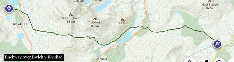
Evans’ 1795 map shows another “ancient trackway” branching to the East at SH65625284, now a footpath which climbs the hill very steeply indeed as a narrow hollow, crossing the A498 at SH65725272, where it becomes nominally a bridleway and continues the steep ascent to cross the skyline by a prominent tump of rock at Bwlch y Rhediad (current OS spelling) or Ehediad (both forms appear on maps of different dates). Thereafter it crosses the headslopes of the Afon Cwm Edno by Sarn Diwaunydd, where there are substantial stepping stones (see below) and gradually descends the hillside directly to Pont Sarn Ddu SH71125158 GAT4619. This route graphically illustrates what a “county road” of 200 years ago as described by Edmund Hyde Hall could mean. It is not shown on OSD of 1818 but reappears on OS 1838 as a path, and E of Sarn Diwaunydd SH68565272 as a road. It is difficult to imagine it would ever have been capable of sustaining wheeled traffic, and there is no evidence it is used even as a bridleway now; the ascent is so steep, rough, and overgrown I doubt whether any rider would wish to attempt it today. Nonetheless there is some scattered metalling, both surface gravel and foundation stones, and the occasional culvert. Beyond the pass it is usually a very rough narrow hollow, sometimes two, and 1891 again labels it “ancient trackway”. (GAT 8364). Across the moor the modern walker needs the very comprehensive waymarking that Conwy council has provided , however when you reach the Sarn there are some very substantial stepping stones (GAT 8266 which has photographs), again suggestive of a drover’s road – once you have got your feet wet getting over the bog immediately to the W of it; and there is some suggestion of a rough embankment where it enters forestry land, which has largely been cleared in recent years. The path becomes almost non existent here, you need to trust the map more than usual. Eventually you reach lower ground and come to Roman Bridge Station. Although it has few regular constructional characteristics, the author of https://www.megalithic.co.uk/article.php?sid=2146412751 who spent three days up here in 2006 argues with some force that it is part of a long distance drove road, and RCAMHW agrees. There are a number of archaeological sites in its vicinity. The route branching S via Moel Goch clatter bridge appears to be secondary version. By descending to the Lledr valley it does provide a means of communication, however primitive, between Nant Gwynant and Llanrwst/Conwy, but the creation of the turnpike, although a mile or two longer, would have made it obsolete. As Hyde Hall says “Before the present turnpike roads were made, [Beddgelert] parish was accessible only by rough and uneven bridle roads”.
W of SH65625284 there was on 1891 a footpath through Hafod Rhisgl across the meadows to what Jenkins mistakenly called “Roman bridge” SH64875273. (GAT11719) The RoW has now been diverted more to the S away from the farm, breaking the immediate connection. This bridge is a substantial clapper bridge, extended following a change of course in the river bed, and a line of RoWs can then be traced from that point S and then W through Bwlch Cwm Llan at SH60575215, just to the W there is a brief section of made packhorse trail disappearing under a quarry tip, then Pen ar Lon, Rhyd Ddu, and probably Bwlch y Moch (“pig pass”, sure sign of a drove road) SH56125398, where by Jenkins account it crosses RR68 qv. Then down past Drws y Coed into the Nantlle Valley via a footpath which has now been adopted as part of the Snowdonia Slate Trail. From Penygroes it leads into the Llŷn peninsula. This section is much more fragmentary, but again shows evidence of a drove road.
2.Pen y Gwryd to Criccieth.
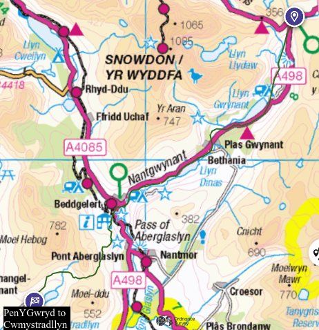
Leaving the Roman Camp at Pen y Gwryd, early OS maps mark the northern end of this route from SH65895547 to SH65845530 as being on the W side of the stream; although some very slight traces are to be found there, there is a more clearly defined track above the E side, coming down to the valley bottom in a reverse curve to cross Nant Cynnyd at SH65715502. Continuing S from there it can be clearly seen from the main road above. The whole trail is mostly a hollow way, sometimes two or even three in parallel, up to 2m deep with a wet bottom even in dry weather conditions. There are no signs of deliberate construction. It is no longer used as a footpath, and is now very difficult to walk, floods or no. For some of its course boulders have been piled up on one side or the other, whether to clear out the bottom, to funnel livestock, or as a marker, one can only guess. It crosses Afon Trawsnant at SH65585467, marked as a ford on 1891 and still easy to negotiate in dry weather, and becomes a modern well used footpath beyond that. After passing an Iron Age or Romano British hut site GAT881 SH65305415 just N of Cwm Dyli power station, it again fords the stream at the valley bottom and continues on the E side of the water as a hollow way. This stretch is no longer a footpath/RoW and becomes more indistinct as the meadows open out. After the modern campsite it merges with the A498 passing close to the site of Hen Capel SH64495169 GAT3399 and reappears on the 1891 maps as the approach road to Bryngwynant youth hostel SH64125141, and in the vicinity of Ysgoldy clapper bridge SH63505144 (GAT11680). which would be a dry foot pedestrian alternative to the ford marked on the trackway in 1891 a little further downstream at SH63285125, where it can still be seen. The approach to to the ford from the N is still a clear trackway below the main road SH63545134.
1795 shows it passing Hafod Y Llan farm and running in with its approach road to the present main road, which 1795 again shows it to have run on much the same course into Beddgelert. At the end of the village it passes the Royal Goat Hotel to the E and climbs the hills as tracks and hollow ways towards Criccieth. That section is still an RoW on the map even though it is now physically under the slate tips of Gorseddau Quarry SH57184522, not an easy route to negotiate, having been made redundant by the turnpike.