W ch 15 proposes a Roman route from Caer Llugwy (Bryn Gefeiliau) /Capel Curig/Llanberis/Segontium. I think it logical that there would be a road between the two forts, although I disagree with some of the details proposed by Waddelove. The earliest written record for such a route is found in 1660 at GAS XQS/1660/165 Presentment for disrepair of bridge over the river Lligwy [phonetic for Llugwy], called Pont y Glynn, situated on the road from Llanrust to Carnarvon. These records, (in which a defective bridge is summonsed to Quarter Sessions to account for itself!) haven’t made it to the Archwilio record. The entry confirms such a route to Caernarfon existed. This is the crossing at SH71845803, which is fordable in dry weather. I have seen it in full winter flood, and you would certainly drown if you tried to cross in such conditions. GAT66132 refers to the turnpike bridge carrying the A4086 in the same location. It is adjacent to the mediaeval Anglican chapel of St Julitta’s GAT6918 https://www.stjulittas.org. Although the chapel itself is deconsecrated, the graveyard is still in use. The original course of the track was to the north of the A4086 which passes Plas y Brenin, and is no longer a right of way. In the other direction the route to Llanrwst, now part of the Snowdonia Slate Trail, lies to the north of the A5. How the Romans would have reached this point from the fort at Caer Llugwy/Bryn Gefeilliau is not clear. Since it is on the S side of the river, it may not have had to use the ford at all. Alternatively GAS XPlans B/184 15/4/1800 Bontnewydd is relevant, since it refers to “Capel Curig to Bettws y Coed” at “Cyfyn issa”, that is Pont Cyfing at SH73435716, GAT74944, a route which passes the Roman fort and is usually regarded as being built after 1802 as a turnpike. Plans for a “new bridge” implies there was an older one it replaced
I have walked much of Ws proposed route through Dyffryn Mymbyr, described in 1891 as “ancient trackway” , and would add only that a painting in possession of a neighbour depicts a now lost bridge at SH66345599 which is consistent with this route. This valley is notorious for its high rainfall, as the Met Office weather station at SH70105705 will tell you. Another Quarter Sessions record 1815 Pont y Gwrhyd XQS/1815/119 April 1 Presentment that a part of the common highway in pa. Llandegai, beginning with a bridge called Pont y Gwychyd and continuing towards Capel Curig, 7,000 yds. long [4 miles, right back to Plas y Brenin] and 18ft. wide, is in a state of disrepair. This shows the new surface had failed within a few years. There was a turnpike at SH59205694 midway along this stretch, which is now Dyffryn Cottages, a holiday cottage owned by the National Trust. The inglenook in it has an oak bressummer beam, not slate, indicative of a pre Industrial Revolution date. None of the documentation for this stretch of the Porthdinllaen turnpike trust has survived, but clearly income was too low for the trust to maintain the road itself. Similar records replicate the situation at Beddgelert and Aberglaslyn.
Beyond Pen y Gwryd W states “the modern A4086 climbs across [the mountain] face to the top of Pen y pass; there are no signs of an earlier road within the few only feet on either side where such could possibly have been”. In fact, there is near continuous evidence just below the main road to the southwest which 1891 again describes as “ancient trackway”. Like most of these features, it is more easily seen in winter/early spring than in late summer, when bracken growth conceals everything. I first walked this section in 2002 prior to the establishment of a courtesy path on roughly the same line in 2016. The features are still visible but are deteriorating in the current very wet climate.
SH65715551 diverges from main road. Rather faint, hollow winding trail with occasional straighter terrace. SH65635543 and SH65505520 clear low terraceway damaged in parts, travelling slightly downhill E to W.
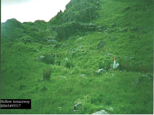
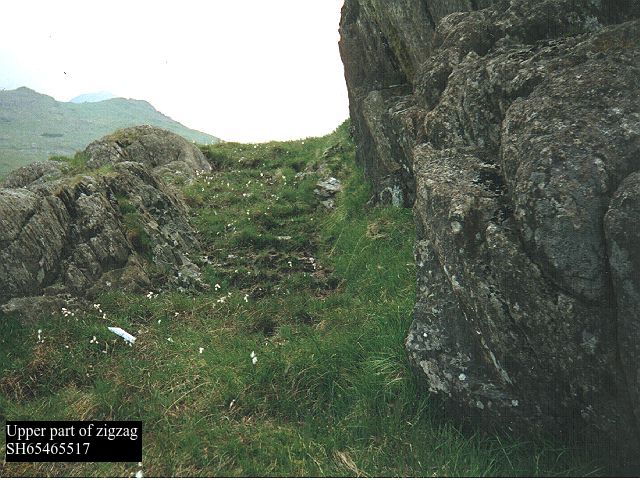
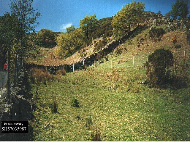
SH65435518 is a zigzag to get to the top of the shoulder of the hill, maintained by the courtesy path and clearly visible on satellite images.
There is then a succession of terraces and hollows until Pen y Pass is reached at SH64735563
1891 then marks trackway on S edge of A4086 but road widening has obliterated any traces, to point SH64585573 where it crossed at oblique angle and ran N of and below main road. A path is marked on 1891 and still on OS 6in 1930 edition, although not on present maps, but initially the traces on the ground are very faint and intermittent, slight terraces and/or hollows, hardly distinguishable were it not for the map evidence. This is boggy ground so remains may have been covered or washed away. By SH63985594 there is virtually no space between the present road and the river, and the line must be under the present road which has been widened from the 1831 turnpike. At SH63935596 1891 marks a footbridge which has gone.
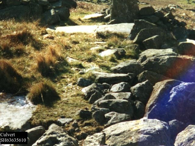
Better evidence emerges as the line diverges from the modern road again with a terrace at SH64505575, with two adjoining hollow ways, then a partially collapsed culvert at SH63635610,
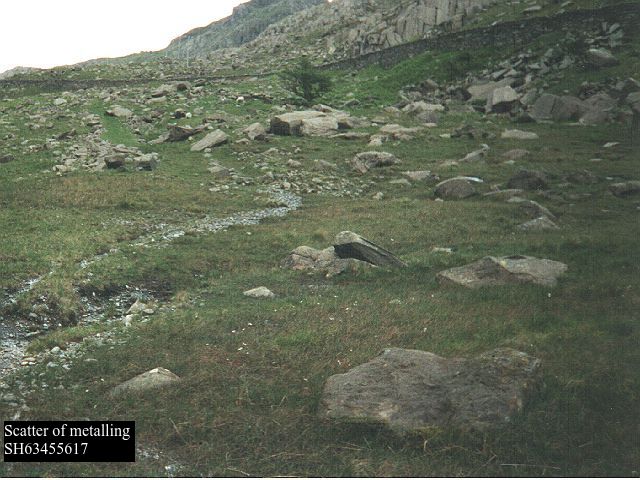
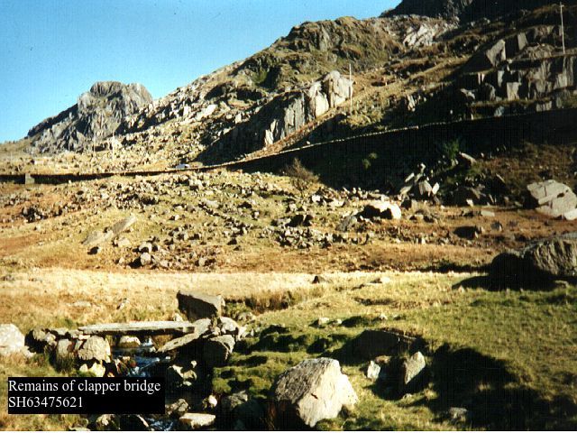
slight hollow at SH63625611, then a very clear terrace with a stone embankment at SH63555610. Where water washes over the line at SH63455617 there is a scatter of metalling, then the track must have crossed/forded Afon Nant Peris as on the OS map at SH63415623. To one side of this line there is a slightly perilous “bridge” of two very large slabs SH63475622 with one of the foundation slabs underneath partially dislodged, recorded on 1891 presumably a packhorse variation.
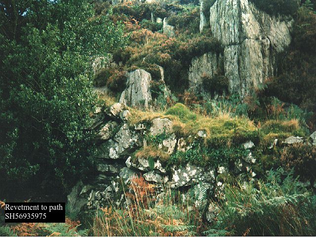
Further slight hollows or terraces are visible at SH63335632, SH63335632, SH63175651, but little evidence at the crossing of the sidestream Afon Bryn at SH63135652. marked as a ford on 1891. All along this stretch there is frequently a hollow path, no more than a foot or so wide, meandering in or beside the traces of the road. The line then falls in, below Pont Gromlech, with W’s photo p285, plate IV . OS maps cease to plot an “Ancient Trackway” from this point on.
Below this on to Nant Peris there is no evidence other than the present A4086, which is as near straight as the topography allows, and when a flood plain begins to develop, runs in the angle between it and the mountainside.
The next clear traces of a track on the southern side of Llyn Peris shows it must have crossed the river again, probably in the vicinity of the present “footbridge” at SH60375826, which now consists of a single very large quarried slate slab. There is a public right of way NE from here until the main road is reached again, then at SH59805878 there are the remains of a terrace by the fence rising gently until it disappears under the first of the slate tips and copper mine workings that together with the modern landscaping have obscured any signs for several hundred metres.
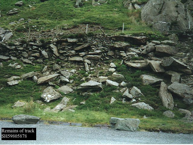
The next clear indication is the remnants of a terraceway leaving the modern lay by at SH59765878, with a fence on its lower side, at first largely cut away by modern roadworks, passing the entrance to a collapsed adit at SH59725881 and then becoming quite clear at SH59635884.

This route, which is presumably that referred to in W p286 note 6, rises some 50m above the modern road as it negotiates the only possible route through the cliff faces of Clogwyn Mawr other than taking what is presumably the turnpike route along the bottom of the cliff beside the lake. On the original OS the difference in height between 1831 road and lake is only 6 feet so it might originally have been effectively impassable. NB there is another largely destroyed terraceway arcing above the present road to pass in front of what is now Bens Cottage at SH59725883, which is a climbing hut and the only building to survive from the copper mine of that name.
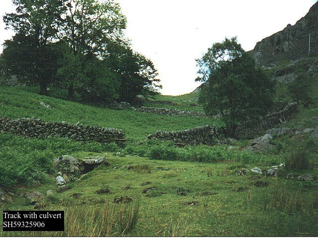
Our route has a narrow spur to reach Bens Mine at SH59495889, where the adit is now blocked by a large rock fall, and passes across a waste tip to go under a wall at SH59645880. This section is no longer a footpath, and is not marked on 1891 although it is shown on 1838 as an access to the copper mine. Fortunately there is a sheep access through which intrepid adventurers can crawl under this very substantial stone wall. It then descends down a side valley towards the lake again, skirting a small boggy patch as a slight terrace showing mainly grass against the predominant bracken, and with some display of metalling in wheel ruts. Passing the abandoned farm of Gweithdy there are again grassy patches in the heather, followed by a sheeptrack, until the route goes under a wall and turns sharply to the left to cross a stream, where there is there is a substantial functioning culvert at SH59325906, close to and clearly visible from the present main road, with a road width about 4m.
There is a second culvert at SH59245905 before the terrace closes with the A4086 at SH59165906. This is the section referred to by RCAMHW p lxii. as SH59505903 to SH59265907, which appears not to have been transferred to Archwilio records.
At SH59045912 an access lane rises to the farm of Cwm Aelhir Uchaf, beyond which there is an unused and rock strewn terraceway leading down to the A4086 again at SH58895940. This last stretch is not on 1891 but is shown as a road on 1838. It is not currently shown as a right of way, although clearly someone thinks it is, because a wicket gate and steps have been constructed at considerable expense to gain access to the abandoned section when the main road was modernized in the 1970s. Beyond this it looks as though it dropped down past Cwm Aelhir Isaf almost to the lake shore, some suggestion of a road line can be seen from the opposite side of the valley, but there is no public access here. Back up at SH58685968 a track bears NE from A4086 (the junction has been substantially modified), and there looks to be a hollow rising from the lakeside to meet up with it. The road then passes W of Dolbadarn Castle as a terraceway SH58575976 which is cut through a slate outcrop, some 8 feet wide.

Beyond on the wooded knoll of Parc Bach there are several terraceways, which presumably reflect routes of different periods and/or for different purposes. On the top of the knoll SH58465974 there is a megalithic structure of unknown date and purpose, GAT4053 = “could be anything from prehistoric to Victorian folly”. Leading up to it on the E side there is a very steep terraceway with a double zigzag. This top would have been an ideal site for a signal station, since there is a clear view back up to the top of the pass on the one side, and on to Bwlch y Groes on the other. A second terraceway appears at SH58475982, clearly revetted then passing through two more small rock cuttings and over the remains of a culvert at SH58395980. The road appears to continue into the grounds of Royal Victoria Hotel a few metres further on. A third roughly parallel narrower terraceway can be seen a few metres further down the hill, presumably a packhorse variant again.
In the modern village 1795 and 1818 both show the main road crossing the Afon Goch at SH57626003. 1795 is not on a sufficiently large scale to show the approach from the SE, but 1818 shows it coming in at a right angle from the Dolbadarn Inn. At the time this was one of the first buildings in the village, reputedly built in 1802, and therefore not shown on the 1795 version. However, the other early building here is Capel Coch, which claims to have been built in 1777 GAT 63972 SH57666003. It could therefore be that the the original road to the SE was more direct, and was blocked off by the construction of this chapel and its Sunday school, which is now the village primary school.
The rest of the route is like deciphering a palimpsest
i) original route . It would appear that the original route headed to Segontium over Bwlch y Groes at a height of 1230ft, SH55705991 and subsequent routes progressively reduced the amount of climbing necessary around the flank of Cefn Du, the most northerly outcrop of the Moel Eilio ridge, until in 1831 the turnpike, essentially the present day A4086, made its way to Caernarfon rather than the Roman settlement. After crossing the Afon Goch at SH57666003. in modern Llanberis, a lane turns up the hillside at SH575356013, which is now the route of the Snowdonia Slate Trail. This rather abrupt turn avoids the route crossing small streams either side of it. There are one or two paths just to the north of this lane passing through Ty Newydd, with traces of a roadway at SH57075992, and at SH57085993 and perhaps the collapsed remains of a zig zag, (clearly suggested in 1891)and another in better condition at SH57055990. There is a terrace closing with the lane SH57025985, quite obvious 20 years ago, but now completely overgrown with bracken.
Just beyond is a path immediately to the N of the present road, which is accessed by a wicket gate at SH57015984. This access is about 1.5 metres above the road level with rough steps up, rather like the geological feature of a hanging valley. There are similar features at SH64545159 and SH58416072 in article Llys Dinorwig to Traeth Mawr, In both cases the later route has worn down sufficiently to create this effect. It then climbs the hill, initially obscured by gorse bushes but then zigzagging very steeply indeed, about 1 in 3 at a guess,
with evidence of a terrace cut through slate bedrock at SH56925977 and possibly a small quarry pit SH56925982. This climbs the S side of the Iron Age hill fort of Dinas Ty- Du SH56675986, GAT4034, and higher up the hill passes below a hut circle described as Romano-British SH56615980 GAT4032.
The path presents as clear grass as distinct from the bracken which has overtaken this hillside. In (increasingly rare) patchy snow it can be clearly seen from the opposite hillside above Llanberis. The path continues as a narrow terraceway slightly hollowed through the slate bedrock on that part of the zigzag which coincides with the dip of the slope, but otherwise largely unworn, occasional evidence of rough kerbstones on the lower side. At times there is residual evidence of side ditches, and also when vegetation is well grown in damp conditions, filled-in drainage channels can be seen running at 45 degrees across the path (a characteristic feature common to most packhorse trails through to more modern paths in the area such as Snowdon Ranger). The terraceway is clearly seen rising to a field gate at SH56735974, and a second at SH56665973. Beyond this the terraceway is again clear at SH56645973, about 6ft wide with side ditches, a typical presentation of a packhorse trail in this part of Gwynedd, (eg Fachwen SH57696169, Nant Peris SH60485904 3et al), and an edge stone at SH56526000 before closing with the existing track over Bwlch y Groes without further evidence at SH56545970. All this is marked as a FP on OS and modern maps, occasionally used by walkers although it has not been classified as a right of way. Coming up to the head of the pas an older line is faintly visible from SH56135983 a few feet above, ie S, of the modern track, used by pony trekkers, with occasional traces of an outer edge and small pits on the southern upper side. Across the hill to the S is a curious feature at SH56005924, a nearly flat shelf of boggy land about 100m x 30m on what is otherwise a very steep hillside, which might possibly be the remains of a long degraded quarrying of the rock which outcrops on this hillside, although it is here siltstone of the Nant Ffrancon formation, rather than the Llanberis slate strata on which the Industrial Revolution quarries are sited.
At the top of the pass the track becomes a tarmac road again – there is a small informal car park here. From SH53775993 to SH53275995 there is a RoW to the north of the lane, shown on 1891, which appears to be a collapsed terraceway. At the road junction SH53106011 it runs straight down to the A4085 at SH51845990. Beyond that a footpath continues the alignment to SH50785971 where it joins my hypothesis for RR68, qv. It is shown on 1891 and I have walked it in the past. However it is now completely overgrown and impassable.
ii)Variation via Maen y Llywd Uchaf . From SH57025985 the tarmac lane, which is still legally a public road although barely useable even by all terrain vehicles, eases this very steep ascent by detouring via ruined Maen Llywd Uchaf at SH56715948. The existence of this latter route from Llanberis to Caernarfon via Bwlch y Groes is apparent from the enclosure map of Llanrug parish, dated 1806, which although it does not show the whole stretch across Bwlch y Groes does show each end on lower ground marked “from Llanberis”, “to Caernarfon”.
iii) Gareg Lefain. At the junction at SH575356013 a lane carries straight on through a wicket gate at SH57306029, which looks like the usual packhorse trail, with a terraceway and a functioning culvert, rejoining the line of the other road shown on 1818 at SH57096036. This lane, now tarmac, passes the ruined Ty Du, GAT83226 SH56976031, the refuge of Bishop Goodman in 1647, “July 31. Petition of Dr. Godfrey Goodman, late Bishop of Gloucester. At the beginning of the late wars, petitioner’s whole estate was sequestered, and, as he had nothing to live upon in London, he was obliged to retire into North Wales, where he lived in a most obscure and mean manner upon the profits of a tenement worth £30 a year, which he had formerly conveyed to pious uses, but was obliged to resume for his own support; and now the Committee for the county of Carnarvon intend to sequester this small remains of his estate, which will expose him to absolute beggary. He prays the House to consider his case, as he is above sixty years of age, very sickly and infirm, to allow him some competent maintenance for the short remainder of his life, and to free his tenement from sequestration” He founded the Ruthin Charities which still survives, and is commemorated by “Goodman Street” in the village. This reference confirms the route existed in 1647.
The modern lane then climbs the hillside with magnificent views at SH566608, where Glyn Rhonwy quarry has been excavated to leave it isolated on a pillar of rock with tunnels underneath, and at SH55416151 a footpath diverges to the W and is eventually seen to be a packhorse trail GAT3875 centred at SH54346166. There is evidence of construction including at least one blocked culvert. It passes across Garreg Lefain and eventually descends to improved land via a zigzag at SH53356143. There is no further trace.
iv) Pen y Bwlch. Continuing up the very narrow tarmac lane which crests the hill at SH55126198, where 1818 shows a house Pen y Bwlch, The modern road now turns sharp left to make a steep descent down the hill. However a right of way goes straight down the hill with evidence of a hollow way. It rejoins the modern lane at SH54856206 and continues past Bryn Bras Castle GAT 4406, built in the 1830s on a mediaeval foundation, SH545625, not on 1795 but shown in 1818, and the lane continues past what is now the rear of the village of Llanrug to fall in with the A4086 at SH52906341.
v) Pont Rug (A4086). The layout of 1795 shows that Pont Rug is an afterthought, as evidenced by GAS XPlans B/151 “3/9/1779 Pont Llanrug – to amend the ‘new bridge’ built in recent years by raising the road at either end”. Before the new bridge, you had to reach Caernarfon by turning west through Caeathro, and approach the town via Segontium, which demonstrates how persistently the apparently Roman approach to Caernarfon via Segontium survived into the 18thC.
vi) Turnpike. Provision for a turnpike from Caernarfon through Llanberis to Pen y Gwryd, to meet the existing Capel Curig – Beddgelert etc road there, was made in the Turnpike Act of 1810 (50 Geo III c. 52) although it was not until 1831 that the work was completed. The A4086 N of Llanberis to the end of Llyn Padarn was built 1825-6. The accounts for construction of this stretch can be found at GAS XD2/13158, which is the account book of the agent’s payments, totalling £1677, to workmen on behalf of Lord Newborough for building the bridge at Penllyn and “some mile and a half of road toward Llanberis”. The road was further improved in 1984 by bypassing Cwm y Glo, as part of the improvement of A roads in the area to service the construction of Dinorwig Power Station. But even today, Pont Rug like other C18th creations in the area is wide enough for two cars with care, but not two HGVs. It’s also flagged on road signs as a weak bridge with an 18 tonne lorry limit, though I doubt it is always observed.
This was the succession of routes that was used to transport copper ore from mines at Nant Peris, and slate which we now know was shipped across Llyn Peris in the C16th. No wonder that Dr Johnson of dictionary fame (who, as it so happens, failed to graduate from my Oxford college) grumbled about the road when he visited Nant Peris in 1773, which he must have done via the Pen y Bwlch version. JMW Turner would have had the same experience when he visited in 1799, though there is no record of his attitude to it.