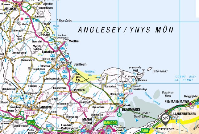
The road Margary RR67 is attested as Iter XI of the Antonine Itinerary, which is the shortest entry in terms of the number of stages. Segontium is a well attested, excavated Roman fort and vicus, which has an afterlife in several Welsh legends. It is reasonable to think of it as the most important Roman presence in North West Wales. It was probably founded by the Roman governor Agricola in AD78 following his victory against the Ordovices. The tribal name survives now as Dinas Dinorwig, and thence as the village name which has migrated a few miles uphill. But this was not the first Roman presence here, since in AD61 the governor Gaius Suetonius Paulinus engaged with the “Druids” in a battle on the Menai Strait (Tacitus Annals 14.29). He then learnt of the Boudiccan revolt started in Camulodunum (Colchester), spreading to London and St. Albans. He had to return south in order to put it down.
The Roman navy would not have been capable of conveying messengers and troops (even allowing for Tacitus’ figure of 10000 as an exaggeration) around the south western end of Cornwall in such an emergency. There must have been a route linking the Menai Strait and London in AD61, but where did that battle take place? I think we are in danger of being blinded by modern topography, most historians assume it must have been either Bangor Ferry, or Moel y Don. But it is well attested both by literature and maps that the main crossing up until the inundation of Lavan Sands, was at what is now called Beaumaris. That is why Edward I built a castle there, to dominate the crossing, just as at Conwy and Rhuddlan. The road over Bwlch y Deufaen can best be viewed as a Romanized trackway, which continued across the Menai Strait to Parys mountain, as described by William Ashton. The section running from Gorddinog to Segontium was added some years later, when the latter fort/town was created in the latter half of the 1st century.
Extract from William Ashton, The Evolution of a Coastline (1920)
“Mr. Elias Owen writes about this road : — ” I well remember 35 years ago (circ. 1859) noticing the ridge or raised roadway then existing, and which there was every reason to believe was a Roman road, raised and paved, going over the sands, and which most likely ended in a ferry opposite Beaumaris.” An 1805 map (Laurie & Whittle, London) shows two distinct tracks to Beaumaris, the one commencing from between Penmaenmawr and Llanfairfechan. and the other from opposite Aber. [1795 shows the same configuration, with the more northerly line marked as a coach road]
Early in the 19th century the fine new coach road through Nantfrancon and the Llugwy Valley, by Corwen, Bettws-y-coed, and Capel Curig, diverted the Irish traffic to the Bangor ferry, the Straits being crossed near the spot selected by Telford, 20 years later, for the building of his great experimental Suspension Bridge. This bridge was opened for road traffic in 1826. Four years later the railway era was inaugurated, and in 1850 Stephenson’s great Britannia Tubular Bridge, about two miles west of the Suspension Bridge, diverted to the Chester and Holyhead railway the bulk of the Irish traffic which Telford’s bridge had been designed to carry. The way from Conway to Beaumaris was joined, before reaching the ferry opposite Beaumaris, by an ancient track which came from the Roman station of Kanovium, or Caerhun (five miles above Conway, up the river Conway), over the mountains through the high pass of Bwlch-y-ddeufaen, and descending to the coast through a narrow valley, Rhiwiau, on the Aber side of Llanfairfechan, opposite Bryn-y-neuadd. In 1883 two Roman milestones, of dates between 119 and 211 A.D. [see GAT4066] were found in this valley, proving by the inscriptions upon them that this road had been used by the Romans as a way of approach from Kanovium to the copper mines at Pary’s Mountain. This Kanovium track over the mountains is one of the earliest of roads across Carnarvonshire of which we have any knowledge. It was part of the Roman road from Chester through Denbigh, Llansannan, and Llan-gerniew to Segontium ; others think through St. Asaph and Bettws- Abergele ; the evidences are very vague. Near Careg Vawr (overlooking Llanfairfechan) the road forked, the left leading through Aber to Segontium, and the right towards Anglesey. The writer has taken some pains to trace the way on Anglesey taken by the Romans to reach the Amlwch copper mines. Precisely opposite the old road across the mountains from Kanovium, near Llanfairfechan, about 3i miles east of Beaumeiris on the Anglesey coast, the old way probably went between Penmon School and the sea ; east of Cornelyn, Llangoed ; above the Methodist Chapel and past the windmill ; then, after a sharp turn to the left, to the hill Marian Dyrys ; by Coed Cywydd Farm and Dinas Sylwy, and thence direct to Red Wharf Bay at a point nearly a mile below its head. Here it is joined by a direct road from Beaumaris, which would be an alternative way from across the Straits. Subsidence having caused the sea to advance up Red Wharf Bay to this extent, the old track is now submerged for about 21 miles of its course. On the opposite, or west, side of the Bay a well-defined road ascends from close to the north side of the Ship Inn ; thence by Llanbedrgoch and Penrhos Llugwy (where quantities of Roman pottery and coins have been found) to the Copper Mines at Pary’s Mountain. It seemed worth while to make this examination, as the support which it gives to the subsidence theory is incontrovertible. A marked characteristic of Roman roads is their directness, a condition well fulfilled in this case.
” The remains of a paved Roman way, according to ” Lewis, may be traced leading through Penmon, ** towards Llaniestyn.” (Williams’ ” Guide to the Menai Straits.”).
This submerged road, whose existence is evident to anyone looking at a detailed map of eastern Anglesey, must be reflect a time when sea level was considerably than it is now, and Penysarn (top of causeway) at the northern end SH459904 is a significant name. Beware of proceeding too far down to the inlets by vehicle on this road, it is very difficult to turn! Now we know that Parys copper mine was worked in the Bronze Age as well as by the Romans, it fits very logically as an ancient trackway like those running east/west further south across the Rhinogau.
Bibliography
1795 Evans J – Map of North Wales (ca 1795). Available online from National Library of Wales.
William Ashton, The Evolution of a Coastline (1920)
GAS refers to Gwynedd Archive Service, Caernarfon
GAT refers to Gwynedd Archaeological trust records.
John Byde 7th April 2022
Thanks for a bit of ancient history on the area my husband and I travelled many years ago as we took the train from Conwy to ferry port at Holyhead to catch the ferry to Ireland. Interesting to see this was a well travelled way between the homelands of our ancestors long before the earliest dates on his family tree. I remember seeing Beaumaris across the water as rode the train and wishing we had time to explore it. After discoverying a long line of Anglican clergy in his family tree I would love to learn more about the cathedrals at Bangor and Beaumaris and a few smaller parishes.
A couple of fascinating notes- Is it likely that Pen Y Sarn is so named as the natural terminus of the roman road/causway (i.e. ‘sarn’)?
In my searching I’ve been unable to divine exactly where a historical lavan sands crossing would have been made in association to the roman roads, but it seems painfully obvious that the roman road indeed descends through gorddinog, which really does not seem to be common knowledge!
I’ve walked the road down to Gorddinog, and there’s no doubt about it, a huge hollow way largely backfilled now. If you look at Evans’ map of 1795, image available at https://www.library.wales/discover-learn/digital-exhibitions/maps/maps-of-wales/evans-map-of-north-wales#?c=&m=&s=&cv=&xywh=-223,-546,10077,7746, you can see he marks two crossings of the Lavan Sands, one from “Penmaen” as a coach road, and apparently a “ferry house” at the crossing. It’s also of course why the unfinished Beaumaris castle was built.
The Ordnance survey marking of Roman roads in Gwynedd is very erratic and often refers to medieval trails or turnpikes.